| Location | Ma'an Governorate, Jordan | |||||
|---|---|---|---|---|---|---|
| Coordinates | 30°19′43″N 35°26′31″ECoordinates: 30°19′43″N 35°26′31″E | |||||
| Area | 264 square kilometres (102 sq mi)[1] | |||||
| Elevation | 810 m (2,657 ft) | |||||
| Built | possibly as early as 5th century BC [2] | |||||
| Visitors | 580,000 (in 2007) | |||||
| Governing body | Petra Region Authority | |||||
 |
||||||

History 
View of the Royal Tombs in Petra
Josephus (Antiquities of the Jews iv. 7, 1~ 4, 7), Eusebius and Jerome (Onom. sacr. 286, 71. 145, 9; 228, 55. 287, 94) assert that Rekem was the native name, and this name appears in the Dead Sea Scrolls[15] as a prominent Edomite site most closely describing Petra, and associated with Mount Seir. But in the Aramaic versions, Rekem is the name of Kadesh, implying that Josephus may have confused the two places. The Semitic name of the city, if not Sela, remains unknown. The passage in Diodorus Siculus (xix. 94–97) which describes the expeditions which Antigonus sent against the Nabataeans in 312 BC is understood to throw some light upon the history of Petra, but the "petra" referred to as a natural fortress and place of refuge cannot be a proper name and the description implies that the town was not yet in existence. 
The Rekem Inscription before it was buried by the bridge
abutments.
More satisfactory evidence of the date of the earliest Nabataean settlement may be obtained from an examination of the tombs. Two types of tombs have been distinguished: the Nabataean and the Greco-Roman. The Nabataean type starts from the simple pylon-tomb with a door set in a tower crowned by a parapet ornament, in imitation of the front of a dwelling-house. Then, after passing through various stages, the full Nabataean type is reached, retaining all the native features and at the same time exhibiting characteristics which are partly Egyptian and partly Greek. Of this type close parallels exist in the tomb-towers at Mada'in Saleh in north Arabia, which bear long Nabataean inscriptions and supply a date for the corresponding monuments at Petra. Then comes a series of tombfronts which terminate in a semicircular arch, a feature derived from north Syria. Finally come the elaborate façades copied from the front of a Roman temple; however, all traces of native style have vanished. The exact dates of the stages in this development cannot be fixed. Few inscriptions of any length have been found at Petra, perhaps because they have perished with the stucco or cement which was used upon many of the buildings. The simple pylon-tombs which belong to the pre-Hellenic age serve as evidence for the earliest period. It is not known how far back in this stage the Nabataean settlement goes, but it does not go back farther than the 6th century BC. A period follows in which the dominant civilization combines Greek, Egyptian and Syrian elements, clearly pointing to the age of the Ptolemies. Towards the close of the 2nd century BC, when the Ptolemaic and Seleucid kingdoms were equally depressed, the Nabataean kingdom came to the front. Under Aretas III Philhellene, (c.85–60 BC), the royal coins begin. The theatre was probably excavated at that time, and Petra must have assumed the aspect of a Hellenistic city. In the reign of Aretas IV Philopatris, (9 BC–40 AD), the tombs of the el-I~ejr[clarification needed] type may be dated, and perhaps also the High-place.
Petra Today
|
|
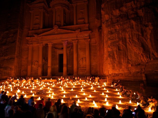
| Today Petra is again the center of attention, at least from
a Middle Eastern perspective. In 1991 41,000 tourists visited
Petra. In 1997 nearly ten times that number made the long trip
through the canyon mouth to stand in awe before the Treasury,
and then to move on through the ancient city streets lined with
tombs, temples, and warehouses. The country of Jordan borrowed some 23 million dollars from the World Bank to build new roads, tourist facilities and other infrastructure in Wadi Musa, the new boom town that has sprung up at the gate to Petra. While this did much to help the flow of tourist traffic, only a small amount was set aside for site preservation. In 1993, Jordan set aside a hundred odd square miles of rugged canyon country as a national park. All through it are steep walled canyons and old caravan roads that once moved frankincense from Oman to Gaza, silk from China to the palaces of Rome and bracelets of gold from workshops in Aleppo to the markets of Yemen. | |


0 comments:
Post a Comment